Carlisle, Massachusetts
Great Brook is in Carlisle, Massachusetts (Carlisle is just north of Concord). Great Brook is about 1,000 acres, and is known for cross-country skiing, dairy cows, ice cream, etc. If you’re not a skier, Great Brook still has much to offer — wide trails, a nice blend of field and forest, lots of Indian structures, lots of interesting boulders, a pond, a brook, a mill site, etc.
Great Brook has a trail called Stone Row, which has several Indian structures. Below is a map of the Stone Row Trail (or part of it); the route begins and ends at a parking lot.
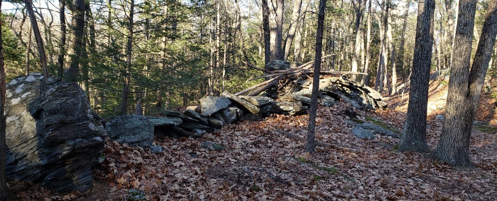
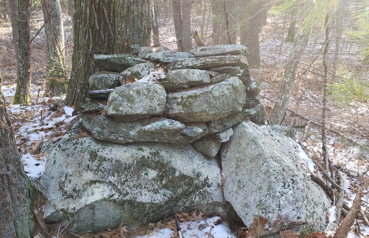
The above route is about 1.5 miles. It features a stone row that points southwest, where the sun sets on the winter solstice. This stone row resembles a stone wall, such as early settlers built, except that it includes a small stone enclosure, and it incorporates large boulders into the row. In the picture below, the trail is on the right, a large boulder is on the left, and in the center-right is a stone enclosure covered with branches.
This isn’t the only stone enclosure on the Stone Row Trail. The picture below shows an enclosure that’s uphill from the trail; like the other enclosure, this enclosure utilizes a large boulder.
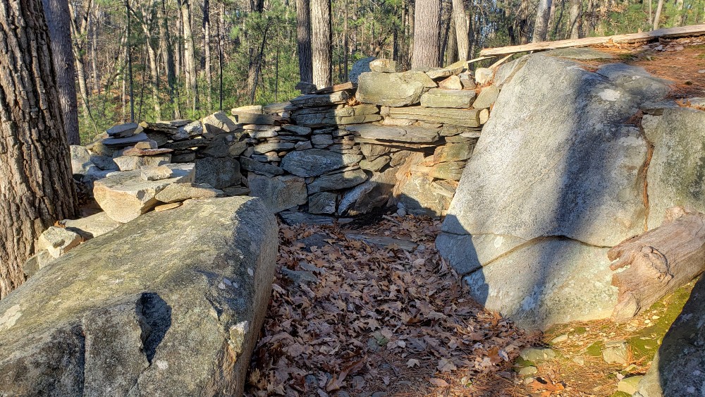
Both enclosures are near the trail, so they’re easy to find. Some of the stonework in the above enclosure is probably from the last twenty years. Assuming that the basic structure is Indian-made, why did the Indians make this structure? Does it align with another stone, and point to the solstice sunset? Is it designed for solitude, for seeking illumination? Or is it designed for society, for getting together? Does it have a military purpose? Or is just a way of leaving one’s mark on the land, so the land feels more like home? The above enclosure reminds me of the enclosures at Queen’s Fort in Rhode Island.
If you want to walk further than 1.5 miles, you can follow the trail network to Wolf Rock, in the southern section of Great Brook, at the end of Wolf Rock Road (you can drive to Wolf Rock Road if you want less walking). In the map above, I put a W on Wolf Rock. (It’s called “Wolf Rock” because a wolf once used it for a den.)
Wolf Rock is actually not one rock but three — three enormous boulders. Two of the boulders (the side boulders) look like erratics. The center boulder is leaning on the other two.

It appears that the center boulder broke off the boulder on the right (the taller of the two side boulders). The boulder on the left seems to be an independent erratic, not a fragment of its comrade.
What’s the approximate weight of one of these boulders? If we assume that a boulder is 10 X 10 X 10, that would give us 1,000 cubic feet. If we assume the rock is granite, which weighs 175 pounds per cubic foot, that would mean that one boulder weighs about 175,000 pounds. The average car weighs only 4,000 pounds.
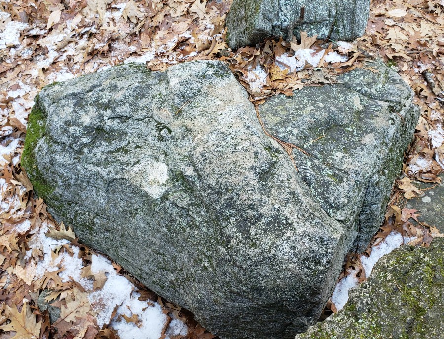
Next to Wolf Rock is a stone effigy of a snake, an effigy made by the Indians. The head of the snake is almost touching Wolf Rock. From here the snake descends to a pond, a distance of about 300 yards, then re-emerges on the opposite side of the pond. For much of its length, the snake looks like an ordinary stone wall. The snake links the erratics to the pond; Indians had a special regard for boulders and for ponds. Linda McElroy, who made a video about Indian stone structures, says that the Carlisle snake contains bends, like a real snake.
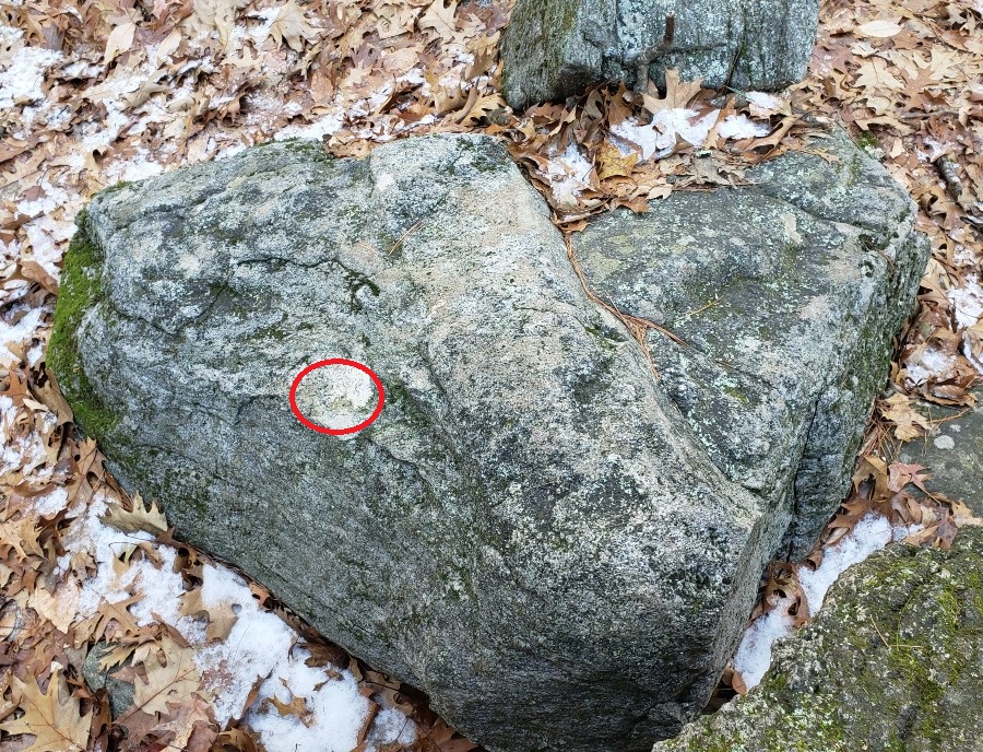
Below is a picture of the snake’s head. Notice that where the snake’s right eye would be is a spot of quartz (as you view the picture, it would be the eye on the left, but for the snake, it would be the right eye). This quartz is about the size of a baseball.
Here’s the same picture; I’ve circled the “quartz eye.” (It may appear to be lichen, not quartz, but when you inspect it closely, I think you’ll find that it’s quartz.)
Quartz had a special significance for the Indians, as I noted when I discussed Boxborough stones.
Did the Indians decide to make a snake effigy, then set out to find a stone shaped like a snake’s head, preferably one with quartz? Or did they come across this stone by chance, and think, “This looks like a snake. Let’s use this stone to make a snake effigy.” In my view, the latter possibility is more likely.
Below is a picture of the snake’s tail; the picture comes from Acton’s Trail Through Time.

Both the head and tail seem to be those of a rattlesnake. After following the snake from its head to the pond/swamp, then walking over the pond when it was frozen, then inspecting the continuation of the snake on the far side of the pond, I was unable to find the snake tail. Then Tim Fohl, who took the tail picture, told me that the tail is about 50 feet before the pond; in other words, it’s not at the end of the snake effigy.
“How can you call it a tail if it’s not at the end of the snake?” Tim’s theory is that the water level was once higher, the tail was once at the end of the snake. My theory is that the tail needed to be on (relatively) flat ground, so they couldn’t make it near the pond.
Below is a bit of stone row that I noticed on the edge of the pond. It seems to have a pattern. Could it be another rattlesnake tail?

Below is a drawing of Wolf Rock, etc.

I told Tim that I thought Indian stone structures, especially those that align with the sun, were a combination of science, religion, and art. He said there’s something more, he said people often feel they’re being pulled into the rock, there are uncanny powers in the rocks. Tim has friends in the NativeAmerican community, and has observed stone structures with Native Americans.
Tim has degrees from Dartmouth and MIT, he had a career as a scientist. He believes there are mysterious powers in the rocks, in the land, especially in Littleton’s Sarah Doublet Forest. He says that several people have independently reported such things, including John Hanson Mitchell, a well-known writer on nature, Native Americans, etc. Mitchell wrote about an uncanny experience, probably in his book Trespassing. Tim asked him if it occurred in Sarah Doublet; he said it did.
Below is a route through the southern section of Great Brook; it visits Wolf Rock; it’s 3.5 miles.
In the above map, I put a K on Keyes Loop and an M on the mill site. There seems to be a stone row on Keyes Loop, a row that connects a pond and a giant erratic, just as the snake connects a pond and giant erratics. This stone row includes a bulge or enclosure:
If you follow the stone row to the pond/swamp, you’ll notice that the stone row turns left, follows the pond for a short distance, then terminates. Here I believe there’s a terminus arrangement (photo below).

Below is the same photo marked. I’ve put a circle around a knob (at the bottom of the picture); this knob makes the stone resemble a manitou stone. I’ve also circled a small stone that acts as a kind of knob, and creates a similar “manitou effect.”

Below is a third copy of the image. I’ve tried to indicate how the stones point toward the terminus, suggesting a careful arrangement, not a random pile such as white settlers would make.

More on Indian stones
Solstice Stones, Boxborough MA
Estabrook Woods, Concord MA
Beebe Woods, Falmouth MA
Maudslay State Park, Newburyport MA
Standing Stones, Smithfield RI
Queen’s Fort, Exeter RI